

OSINTFlow
Against the background of recent pleasant events when following the course of the cruiser “Moscow”⛴ “Sergei Kotov” and “Cesar Kunikov” were sent, we decided to update and supplement our selection of useful resources for those interested in naval topics and OSINT.
Shiplocation – a map of the location of ships. Tracking in the database: more than 80,000 sea and river vessels, 17,000 ports and piers, 1,400 cruise ports, 1,370 sea airports, 1,000 shipyards, etc.
MarineTraffic is an open, community-based project that provides (near) real-time information on vessel movements and locations. Free version – 7 days.
My Ship Tracking is a free Automatic Identification System (AIS) service. The website contains information about ships, ports, and companies.
Shiptraffic.net is a website that tracks vessel traffic and shows the current location of ships using marinetraffic.com and vesselfinder.com embedded maps (dual embedded map).
VesselFinder is a real-time vessel map.
Free Vessel Tracking – search by vessel name / IMO / MMSI or select the desired vessel from the database.
Marine MAN is the site of a crewing company with offices in Ukraine, Estonia and Poland. The resource contains open data provided to sailors by the International Maritime Organization (IMO) about sea vessels and their characteristics with job descriptions.
Balticshipping.com is a seafarer employment service. Information on vacancies contains the characteristics and description of ships, photos, names, etc.
Crewll.net – monitoring vacancies and information on ships.
Q88 is a platform that provides comprehensive solutions for document flow management in the field of maritime shipping and beyond. A search by ship name and IMO provides detailed information on the vessel.
FotoFlite is a huge library of marine aerial photos.
Scheepvaartwest.be – photo database sorted by categories: tankers, cruise liners, fishing vessels, container ships, etc. Most of the pictures were taken in Belgian and Dutch ports.
Shipspotting.com is a community of people who like to photograph ships. Photos of ships and their parts are published (more than 2 million photos).
ShippingExplorer – locates and provides comprehensive information about ships. Full reports are paid. There are applications on Android and iOS .
SeaTracker – AIS. Ship movement map in real time.
Track Trace – tracking of a transport container by number (170 companies).
Container tracking – tracking of a transport container by number.
Searates Container Tracking – Track your shipping container by number. The container tracking system allows you to determine the current location on the world map.
CMA Voyage Finder – search for flight details by flight number or ship name.
The Shipping Database is a research project, a complete archive of the world’s ships (there is data for the year 1900 as well).
Submarinecablemap.com – a map of submarine communication cables. A free resource that is constantly updated.
SUBMARINE TRACKER – submarine tracking map.
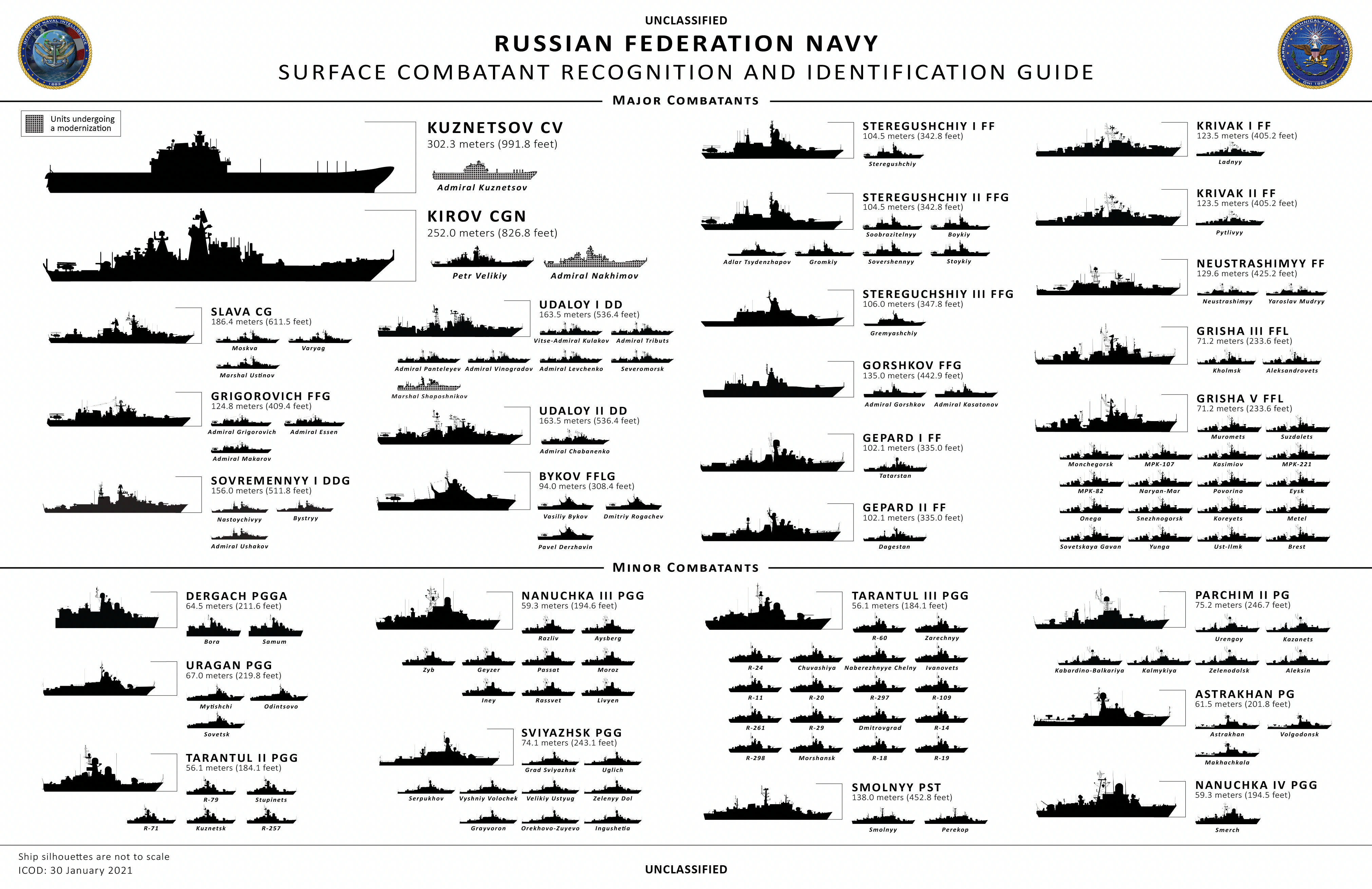
Infographics : russia ship silhouettes – infographic from the website of the US Naval Intelligence (Office of Naval Intelligence) for recognition and identification of Russian surface ships.
Black Sea Fleet – Black Sea Fleet of the Russian Navy based on open sources as of fall 2023.
A selection of X accounts of researchers and analysts : @CovertShores – HI Sutton analysis and visualization.
Site
@TheShipYard2 – TheShipYard. Naval history, 3D models, illustrations. Site
@GrangerE04117 – researcher of military topics, especially interested in the fleet of the Russian Federation.
@KaptainLOMA Frederik Van Lokeren is a former Belgian Navy officer and now a naval analyst.
@NavyRecognition – Online Media. Site


